「★ 怪しい台風 ★」★ Suspicious Typhoon ★
「林 千勝 Hayashi Chikatsu@ChikatsuHayashi7:54 PM · Aug 30, 2024
★ 怪しい台風 ★
【毎日新聞】
西日本を横断している台風10号が「消えた」という投稿が、30日朝からSNSで相次いでいる。
気象庁のウェブサイトにある衛星画像を見ると、どれが台風かわかりにくくなった。どこまでが台風で、どこからが熱帯低気圧なのか。気象庁に聞いた。
「台風が消えた。テレビの予報で大騒ぎしてたけど拍子抜け」
「台風ってホントにあるの? 気象庁の気象衛星画像には写ってないんだけどな……」
X(ツイッター)には30日朝から台風の存在を疑う投稿が相次ぎ、「台風消滅」という言葉がトレンド入り。
さらには、「気象庁が嘘(うそ)をついている」「テレビの台風情報はフェイクだ」と、気象庁の発表や報道内容を疑う投稿もみられた。
その根拠とされたのが、気象衛星ひまわりが撮影した画像 。
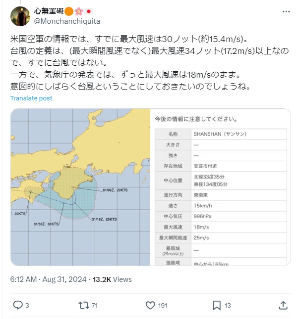
記者が気象庁のウェブサイトで確認すると、30日午前11時の画像では、はっきりとした雲の渦や台風の目が見当たらない。しかし、同じウェブサイトの「台風情報」のページを見ると、台風の中心は大分県の東の海上にある。
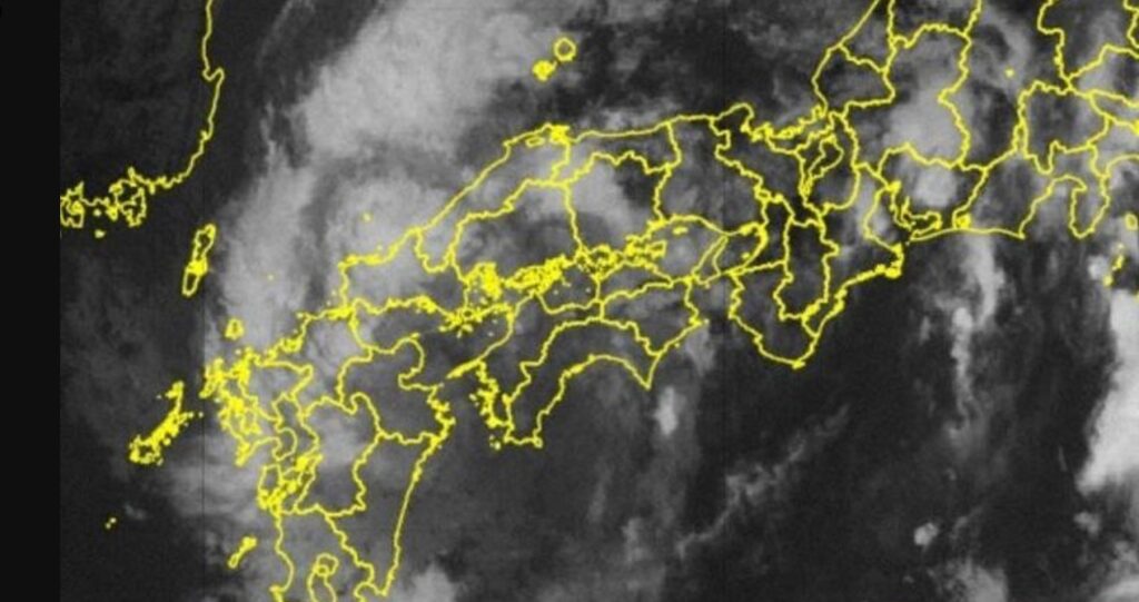
29日午前6時時点の衛星画像をさかのぼって確認すると、鹿児島を中心に大きな雲の渦がはっきりと写っている。この二つの画像を見比べると、台風らしい雲が1日の間に消えてしまったよう。
記者が30日午前、気象庁に問い合わせると、担当者は「台風10号は消えていません」と明言。
北西太平洋や南シナ海にある熱帯低気圧が発達し、最大風速が秒速17メートルを超えると、台風と呼ばれるようになる。台風は海上から供給された水蒸気による熱のエネルギーにより発達するが、北上して次第に水蒸気が供給されなくなると勢力が弱まる。最大風速が秒速17メートルを下回ると熱帯低気圧に移行したとみなされる。
台風10号は30日午前11時現在、勢力は弱まったものの最大風速20メートルを観測している。つまり、台風の基準を満たしている。
衛星画像について、気象庁の担当者は「台風は弱まる過程で、衛星画像上に雲がはっきり写らなくなる。しかし、衛星以外の観測データから台風は消滅していないと判断できる」と指摘。
気象庁は、台風10号は31日から9月1日の間に熱帯低気圧に変わると予想。担当者は「熱帯低気圧に変わっても雨が強まることはあるので、引き続き土砂災害や河川の氾濫に警戒してほしい」と呼びかける。
★ Suspicious Typhoon ★
[Mainichi Shimbun]
Since the morning of the 30th, there have been a series of posts on social media claiming that Typhoon No. 10, which is crossing western Japan, has “disappeared.”
When I look at the satellite images on the Japan Meteorological Agency’s website, it becomes difficult to tell which are typhoons. Where does the typhoon end and where does the tropical depression begin? I asked the Japan Meteorological Agency.
“The typhoon has disappeared. There was a big fuss about it on the TV forecast, but I was surprised.”
“Do typhoons really exist? They don’t even show up on the Japan Meteorological Agency’s weather satellite images…”
From the morning of the 30th, there were a series of posts on Twitter doubting the existence of the typhoon, and the phrase “typhoon disappeared” became a trending topic.
Furthermore, there were also posts expressing doubt about the JMA’s announcements and reports, saying things like, “The JMA is lying,” and “The typhoon information on TV is fake.”
The basis for this was images taken by the Himawari weather satellite.
When the reporter checked the Japan Meteorological Agency’s website, he could not see any clear cloud vortexes or the eye of the typhoon in the image taken at 11:00 a.m. on the 30th. However, when he looked at the “Typhoon Information” page of the same website, he found that the center of the typhoon was located in the sea east of Oita Prefecture.
Looking back at satellite images from 6 a.m. on the 29th, a large vortex of clouds can be clearly seen centered on Kagoshima. Comparing these two images, it seems that the typhoon-like clouds disappeared within a day.
When a reporter inquired at the Japan Meteorological Agency on the morning of the 30th, a representative stated, “Typhoon No. 10 has not disappeared.”
When a tropical cyclone in the Northwest Pacific or South China Sea develops and its maximum wind speed exceeds 17 meters per second, it becomes known as a typhoon. Typhoons develop due to the thermal energy of water vapor supplied from the ocean, but as they move northward, the supply of water vapor gradually decreases and they weaken. When the maximum wind speed falls below 17 meters per second, they are considered to have transitioned into a tropical cyclone.
As of 11:00 a.m. on the 30th, Typhoon No. 10 had weakened but was still recording maximum wind speeds of 20 meters per second. In other words, it still met the criteria for a typhoon.
Regarding satellite images, a JMA official pointed out, “As the typhoon weakens, clouds will no longer appear clearly on satellite images. However, observational data other than from satellites indicates that the typhoon has not disappeared.”
The Japan Meteorological Agency predicts that Typhoon No. 10 will weaken into a tropical depression between the 31st and September 1st. A representative said, “Even if it weakens into a tropical depression, the rains can intensify, so please continue to be on guard against landslides and river flooding.”
」
カテゴリー
歯科矯正コラム一覧
- 「マグヌス効果」知ってますか?・・・練習してみて・・・
- 職人さんは神様だア!「 隙間ゼロの加工術! 驚きの方法!」
- マジック!やってみて!
- 「木材を究極に一体化させる「魔法のビット」」職人さん、偉い!
- 「優雅さが溢れてる ╰(*´︶`*)╯♡」
- 「イギリスのブロガーが自費で数千ドルをかけて日本の軽自動車の航続距離をテストした結果やばすぎる 4794 高評価数 435,605 視聴回数 3月14日」
- バイトも様々・・・見かけとはずいぶん違う・・・
- 手仕事:「世界に誇る『日本人』職人さん」・・・誠実(せいじつ)で、超絶技巧(ちょうぜつぎこう)の職人(しょくにん)さん・・・
- 手仕事:「釘を使わない丈夫な建物の秘密 日本の大工技術」・・・誠実(せいじつ)で超絶技巧(ちょうぜつぎこう)の大工(だいく)さん:今一番求められている人たち
- 手仕事:「#195 南部鉄器職人 阿部亘 | 明日への扉 by アットホーム」誠実(せいじつ)な職人(しょくにん)さんは爽(さわ)やか・・・